A Stratigraphic Study of
the 610 A.D. Eruption of the Mono Craters
A SURF Proposal by Aron
Meltzner
Collaborating with Matthew
Dawson
Mentor: Kerry Sieh
Submitted: 2 March 1998
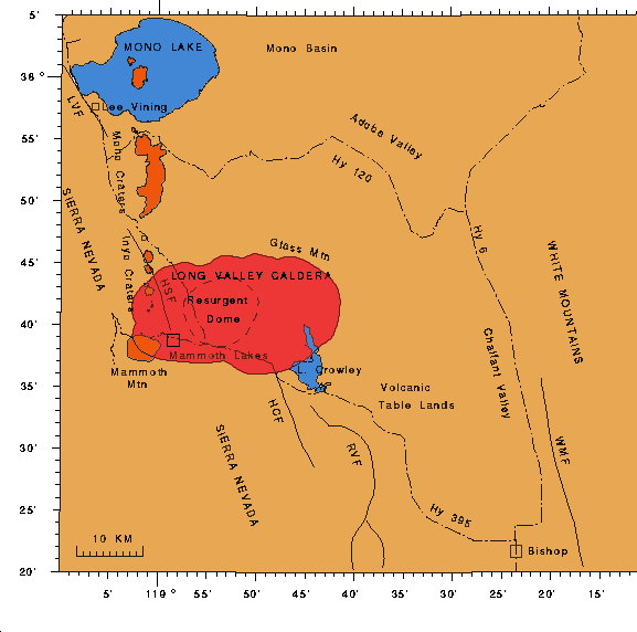
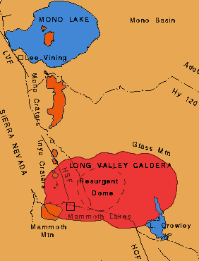 Although
much attention has been focused recently on the Long Valley caldera resurgent
dome in eastern-central California and on associated volcanic hazards at
Mammoth Mountain, little is known about the details of the most recent
(latest Pleistocene to Holocene) eruptions in the greater Long Valley caldera
complex, specifically in the Mono and Inyo Craters chain. In general, activity
within the resurgent dome has not been linked with the formation and later
eruptions of the Mono and Inyo Craters, however, there may be good reason
to connect the two. Despite recent activity in the resurgent dome east
of Mammoth Mountain, the resurgent dome has experienced eruption only once
every 100,000 to 200,000 years since the catastrophic caldera-forming event
760,000 years ago, and it last erupted roughly 50,000 years B.P.; meanwhile,
an eruption has broken out in the nearby Mono-Inyo chain roughly every
250 to 750 years during the past 5,000 years, and an event such as the
latter is statistically more probable in the near future than an eruption
of the resurgent dome. Dr. Kerry Sieh has hypothesized that the Holocene
eruptions of the Mono and Inyo Craters may have immediately followed magmatic
intrusions into the resurgent dome and subsequent lateral sub-surface evacuation
of that magma into adjacent magma chambers under the Mono-Inyo chain (Sieh,
personal communication); such a phenomenon has been observed elsewhere,
particularly in association with events at Kilauea and during the 1912
eruption at Katmai, Alaska, and it could explain the otherwise unlikely
observation that the Long Valley caldera resurgent dome has been expanding
over the past two decades. The validity of such a hypothesis would provide
a direct link between the Long Valley caldera resurgent dome and the Mono-Inyo
Craters chain, and in light of recent seismic activity, this could significantly
increase the potential volcanic hazard in the Mono-Inyo Craters chain in
the near future.
Although
much attention has been focused recently on the Long Valley caldera resurgent
dome in eastern-central California and on associated volcanic hazards at
Mammoth Mountain, little is known about the details of the most recent
(latest Pleistocene to Holocene) eruptions in the greater Long Valley caldera
complex, specifically in the Mono and Inyo Craters chain. In general, activity
within the resurgent dome has not been linked with the formation and later
eruptions of the Mono and Inyo Craters, however, there may be good reason
to connect the two. Despite recent activity in the resurgent dome east
of Mammoth Mountain, the resurgent dome has experienced eruption only once
every 100,000 to 200,000 years since the catastrophic caldera-forming event
760,000 years ago, and it last erupted roughly 50,000 years B.P.; meanwhile,
an eruption has broken out in the nearby Mono-Inyo chain roughly every
250 to 750 years during the past 5,000 years, and an event such as the
latter is statistically more probable in the near future than an eruption
of the resurgent dome. Dr. Kerry Sieh has hypothesized that the Holocene
eruptions of the Mono and Inyo Craters may have immediately followed magmatic
intrusions into the resurgent dome and subsequent lateral sub-surface evacuation
of that magma into adjacent magma chambers under the Mono-Inyo chain (Sieh,
personal communication); such a phenomenon has been observed elsewhere,
particularly in association with events at Kilauea and during the 1912
eruption at Katmai, Alaska, and it could explain the otherwise unlikely
observation that the Long Valley caldera resurgent dome has been expanding
over the past two decades. The validity of such a hypothesis would provide
a direct link between the Long Valley caldera resurgent dome and the Mono-Inyo
Craters chain, and in light of recent seismic activity, this could significantly
increase the potential volcanic hazard in the Mono-Inyo Craters chain in
the near future.
The Mono and Inyo Craters comprise a young
volcanic chain with a violent and exciting history, and there is strong
evidence that another eruption in the region is very likely in the near
geologic future. It is imperative that we study the records of what has
occurred in the region, to help us understand the nature of past eruptions
-- i.e., volume and explosiveness of the eruptions; extent of pyroclastic
falls and flows, lava flows, and ash falls; and the timing of the events
(e.g., if three or four separate vents erupted in the same eruption, did
they erupt contemporaneously, or were the individual vent eruptions separated
by a week, a few months, or more?) -- so that we can gain insight into
what may happen in the future. Sieh and Bursik have already done a thorough
field investigation of the most recent (14th century A.D.) eruption of
the Mono Craters, but that is only one eruption; others still need to be
studied. Dr. Sieh has continued the study by beginning an investigation
of the 610 A.D. eruption of the Mono Craters, although much data has yet
to be collected, and much analysis remains to be done. As a SURF project
this summer, I propose a study in which I1 continue the research
of Dr. Sieh, by collecting more data in the field, and by processing, mapping,
and analyzing the new data subsequently in the GIS (Geographical Information
Systems) computer lab.
There is too much data to be collected and
too many questions to be answered, to even attempt to accomplish everything
in one summer, but with adequate preparation, scrupulous (but systematic)
note-taking, and good judgment in the field, significant progress can be
made toward answering some of the most important questions. We2
will spend approximately five weeks in the field,3 digging pits
at strategically-planned sites, and studying the stratigraphy of the rocks
in each pit. For each volcanic layer, we will note its color, grain or
clast size, texture, mineralogy, and any bedding structures such as cross-bedding,
all of which will help us correlate volcanic layers from one site to the
next. We will interpret each layer's depositional nature (i.e., pyroclastic
flow, lava flow, ash fall, etc.) from its geographical distribution and
the size distribution of its rock fragments. The sorting of a layer's ash
and clasts will allow us to infer the original water content of each layer,
and hence to infer the viscosity and explosiveness of the primordial lava
as well. We will note how the thickness of each layer varies with proximity
to a potential source vent, and if we are able to obtain enough data, we
will interpolate to get an estimate of the volume of material in that particular
layer. We will pay close attention to the boundaries of each layer, provided
we get said data -- if a layer "pinches out" at a particular
point, we know the depositional extent of that particular layer; but if
a layer does not "pinch out" and instead merges with another
layer of different composition, we will have gained the valuable information
that two vents, with separate magmatic sources, were erupting and depositing
ash and debris contemporaneously. Otherwise, we will be able to interpret
the sequence of eruptive events simply by noting the order in which the
beds were deposited.
In addition to taking notes (and photos)
in the field, we will be using a GPS hand-held receiver to determine the
latitude and longitude of each site (+/- 50 m), and we will record on site
on a portable laptop computer, the thickness of each layer at each pit,
and other relevant information. The ArcView GIS application we will be
using will allow us to store and analyze the information we input as data
points, along with the surveyed coordinates for each site. Either in the
field or in the lab when we return, we will analyze the data, using spreadsheets
and graphical methods (in particular, compiling contour maps) as appropriate
to map out the extent and varying thickness of each bed, and to map out
various cross-sections that will reveal the "big picture": the
spatial and temporal depositional distribution of the eruptive material
as a whole. We will spend the final weeks of the SURF interpreting the
data, attempting to explain our findings (and attempting to pinpoint the
source vents or craters of the 610 A.D. eruption), possibly comparing our
data to the data already collected from the 1350 A.D. eruption, or perhaps
we will discover some intriguing pattern or anomaly, which we will want
to focus our attentions on during the last few weeks of the SURF. It is
hard to predict exactly what we will find, but most certainly, the knowledge
we gain will be invaluable in improving the science community's general
knowledge of the Holocene history of the Long Valley caldera complex, and
it will shape the general understanding of volcanic hazards in the region
now, and into the future.
1 and Matt Dawson, another
prospective SURF student
2 Matt Dawson and I, along
with Kerry Sieh, who will be out in the field with us for about two weeks
3 Accommodations are being
provided by a private donor, although we will be camping on-site for several
days at a time.

*** Go back to my research
page! ***
This page initiated
26 March 1998.
Maintained
by Aron Meltzner.
 Although
much attention has been focused recently on the Long Valley caldera resurgent
dome in eastern-central California and on associated volcanic hazards at
Mammoth Mountain, little is known about the details of the most recent
(latest Pleistocene to Holocene) eruptions in the greater Long Valley caldera
complex, specifically in the Mono and Inyo Craters chain. In general, activity
within the resurgent dome has not been linked with the formation and later
eruptions of the Mono and Inyo Craters, however, there may be good reason
to connect the two. Despite recent activity in the resurgent dome east
of Mammoth Mountain, the resurgent dome has experienced eruption only once
every 100,000 to 200,000 years since the catastrophic caldera-forming event
760,000 years ago, and it last erupted roughly 50,000 years B.P.; meanwhile,
an eruption has broken out in the nearby Mono-Inyo chain roughly every
250 to 750 years during the past 5,000 years, and an event such as the
latter is statistically more probable in the near future than an eruption
of the resurgent dome. Dr. Kerry Sieh has hypothesized that the Holocene
eruptions of the Mono and Inyo Craters may have immediately followed magmatic
intrusions into the resurgent dome and subsequent lateral sub-surface evacuation
of that magma into adjacent magma chambers under the Mono-Inyo chain (Sieh,
personal communication); such a phenomenon has been observed elsewhere,
particularly in association with events at Kilauea and during the 1912
eruption at Katmai, Alaska, and it could explain the otherwise unlikely
observation that the Long Valley caldera resurgent dome has been expanding
over the past two decades. The validity of such a hypothesis would provide
a direct link between the Long Valley caldera resurgent dome and the Mono-Inyo
Craters chain, and in light of recent seismic activity, this could significantly
increase the potential volcanic hazard in the Mono-Inyo Craters chain in
the near future.
Although
much attention has been focused recently on the Long Valley caldera resurgent
dome in eastern-central California and on associated volcanic hazards at
Mammoth Mountain, little is known about the details of the most recent
(latest Pleistocene to Holocene) eruptions in the greater Long Valley caldera
complex, specifically in the Mono and Inyo Craters chain. In general, activity
within the resurgent dome has not been linked with the formation and later
eruptions of the Mono and Inyo Craters, however, there may be good reason
to connect the two. Despite recent activity in the resurgent dome east
of Mammoth Mountain, the resurgent dome has experienced eruption only once
every 100,000 to 200,000 years since the catastrophic caldera-forming event
760,000 years ago, and it last erupted roughly 50,000 years B.P.; meanwhile,
an eruption has broken out in the nearby Mono-Inyo chain roughly every
250 to 750 years during the past 5,000 years, and an event such as the
latter is statistically more probable in the near future than an eruption
of the resurgent dome. Dr. Kerry Sieh has hypothesized that the Holocene
eruptions of the Mono and Inyo Craters may have immediately followed magmatic
intrusions into the resurgent dome and subsequent lateral sub-surface evacuation
of that magma into adjacent magma chambers under the Mono-Inyo chain (Sieh,
personal communication); such a phenomenon has been observed elsewhere,
particularly in association with events at Kilauea and during the 1912
eruption at Katmai, Alaska, and it could explain the otherwise unlikely
observation that the Long Valley caldera resurgent dome has been expanding
over the past two decades. The validity of such a hypothesis would provide
a direct link between the Long Valley caldera resurgent dome and the Mono-Inyo
Craters chain, and in light of recent seismic activity, this could significantly
increase the potential volcanic hazard in the Mono-Inyo Craters chain in
the near future.